- Precision (P),
- Recall (R),
- Overall Accuracy (A),
- F-measure,
- Processing time
- Creativity, Innovation and Novelty
In collaboration with Mohammed Bin Rashid Space Centre (MBRSC) and Amazon Web Services (AWS), startups are encouraged to participate in a space-tech pitch challenge to develop a product, solution or application that supports the UAE’s environmental initiatives. Noting that all startups must be participating at VISTA 2021.
Palm trees are considered a symbolic agricultural heritage in the United Arab Emirates (UAE). Date palms constitute 98% of fruit trees in the UAE, which is one of the world’s top ten producers of dates. This is due to the great efforts carried out in the planting management and applying the best practices in ensuring the health status as well as maintaining the production rate, which indeed requires frequent mapping and monitoring. The traditional way of mapping palm trees relies on manual implementation, which results in low accuracy, time consumption and labor intensive. Remote sensing technology, including satellites and Unmanned Aerial Vehicles (UAVs), has contributed to providing potential solutions in terms of large areas coverage, spatial and spectral information.
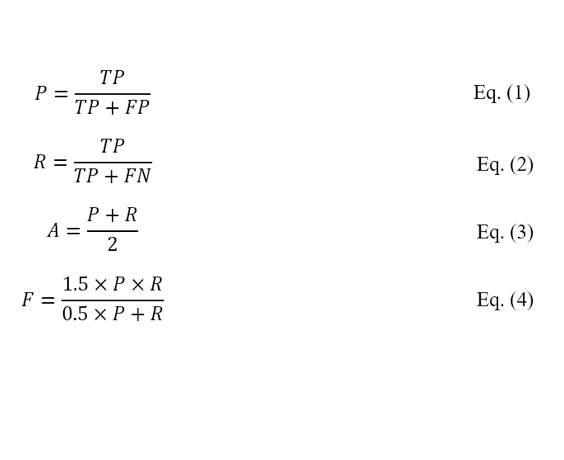
The aim of this challenge is to develop an end-to-end deep learning or machine learning model to automatically detect all the palm trees from RGB aerial imagery, with efficient computational time. N aerial images consisting of more than 250,000 palm trees will be given to the participants for labelling and trainings purposes. In order to evaluate the efficiency of the developed models, the judges will test the models on an image consisting of around 500 palm trees. Precision (P), Recall (R),, Overall Accuracy (A) and F-measure (F) are the performance metrics that will be used to evaluate a model’s efficiency and effectiveness, described in equations (1), (2), (3) and (4) respectively. True Positive (TP) represents the number of palm trees correctly detected by the developed model, False Positive (FP) indicates the number of objects that are incorrectly detected as palm trees, and False Negative (FN) is the number of undetected palm trees. F-measure indicates the harmonic mean of Precision and Recall, and hence, higher P and R values result in higher F-measure. The processing time is another evaluation metric that will be taken into consideration.
Finalists will receive mentorship from MBRSC and AWS to support onsite pitches and solutions. Please view the competition timeline below:
Judge 1 - Eng. Alya AlMaazmi, Head of Remote Sensing Applications Unit, MBRSC
Judge 2 - Prof. Rami Al-Ruzouq - University of Sharjah
Judge 3 – Abdallah Touhami - Senior Managing Director and Accenture’s Aerospace and Defense Lead in the Middle East region
Judge 4 – TBC
Judge 5 – TBC
The 6 finalists will receive Amazon Web Services Credits to the values below whilst also have the exclusive opportunity to be mentored by representatives from MBRSC and Amazon Web Services. Both MBRSC and AWS will dedicate time in the run up to the live event to support the 6 finalists to ensure each startup has the best resources available to build the ultimate solution.
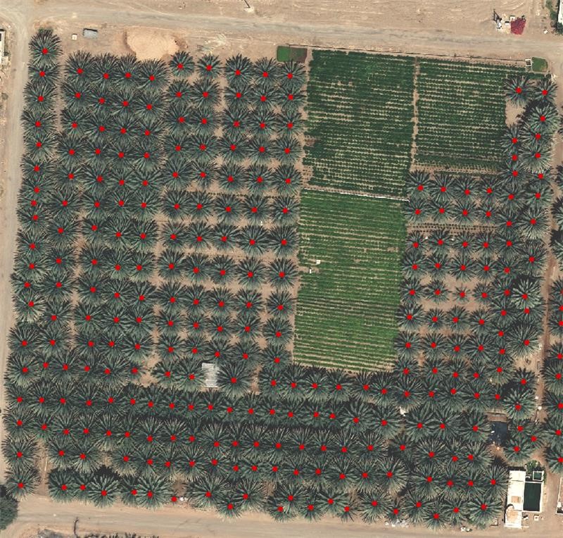
The results must be submitted as a vector file (.shp) representing each individual palm tree in an image as a point as shown in figure 1.
Figure 1. Example of the expected output
The competitions have now closed for entries, we hope you will join us to see the finalists pitch live onsite during Vista 2021!